
College of Agriculture and Natural Resources
Center for Land Use Education and Research

Please be sure that you understand the data and its appropriate (and inappropriate) uses.
Information about the forest fragmentation datasets:
Forest Fragmentation Frequently Asked Questions
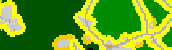
Forest Fragmentation categories.
Caution! Before You Use These Data . . . contains information about the land cover data.
Information for GIS Users:
All data are zipped. You must have winzip to extract the files. Get winzip.
All data are Connecticut State Plane NAD83 feet.
Looking for shapfiles? We do not provide them, but click here for some information and instructions.
The forest fragmentation datasets only include forest areas. To recreate the maps as seen on the Your Town page and Your Watershed pages, it is necessary to display the forest fragmentation dataset with the background dataset. Click here for instructions.
Click here to see a table of legend colors with RGB values.
In ArcGIS, the imagine files provided are best viewed as Unique Values, not Colormap. Change this setting in the layer properties, symbology tab.
Entire Study Area* |
Connecticut |
By Planning Region |
 |

|
 |
*The area includes the state of Connecticut, all local watershed basins that intersect the state, and all towns (including MA) in the Quinebaug-Shetucket National Heritage Corridor.
The following zip files contain .img files and .rrd files. The .img files contain the pixel data and the .rrd files are pyramid layers that help drawing speed.
(includes all of Connecticut, and intersecting watersheds of NY, RI, and MA)
| Imagine format (*.img) |
1985 (2.4 Mb) |
1990 (2.4 Mb) |
1995 (2.4 Mb) |
2002 (2.4 Mb) |
2006 (3.9 Mb) |
Change (2.7 Mb) |
| Imagine format (*.img) | 1985 (2.7 Mb) |
1990 (2.7 Mb) |
1995 (2.7 Mb) |
2002 (2.8 Mb) |
2006 (2.8 Mb) |
Change (5.1 Mb) |
Don't know what planning region your town belongs to? Click here.
If You are Looking for Shapefiles . . .
We do not provide shapefiles primarily because of the large file sizes and also because it is so easy to do the conversion in ArcMap. See instructions below. Before doing the conversion, be sure you actually need shapfiles. For simple viewing and analyses, the rasters work as well, and sometimes better than shapefiles. If you are still having trouble or have questions, email us at clear@uconn.edu.
It is easy to convert these raster files to shapefiles in ArcMap. We highly recommend doing the conversion on small geographic areas. Statewide land cover shapefiles are unwieldy to work with and are very large files (200 MB+).
First, download the raster files from this page.
In ArcToolbox, locate the Conversion Toolbox and the From Raster Tools.
Open the Raster to Polygon tool.
Select the Input raster file.
Select the Field. We recommend selecting Class so that the attribute table will have both gridcode and class_name. If you select Value, that works too.
UNCHECK simplify polygons. That's important.
That's it!
Adding Background to the Forest Fragmentation Datasets
1. Be sure all non-forest classes are not visible. Depending on the software, you could accomplish this by removing them from display, setting a no color or transparent color, changing the opacity to 0 or setting the color to null.
2. Visit the land cover download page and download the appropriate area and data to be used for the background. The land cover area and date should correspond to the forest fragmentation area and data.
| Developed | |
| Other Land Cover | |
| Water |
3. Change the symbology of the land cover. In the maps shown here
4. Be sure the background image is underneath the forest fragmentation image.
| Class Number |
|
R |
G |
B |
|
| 1 | Patch | 230 | 152 | 0 | |
| 2 | Edge | 255 | 255 | 0 | |
| 3 | Perforated | 243 | 204 | 0 | |
| 4 | Small Core (<250 ac) | 0 | 140 | 0 | |
| 5 | Med Core (250-500 ac) | 0 | 107 | 0 | |
| 6 | Large Core (500+ ac) | 0 | 84 | 0 |
