Study Area | Sub-regional Watershed Characterization | Riparian Buffer Creation & Analysis | High Resolution Analysis | Project Completion Report
The first task was to determine the study area that would be analyzed. For this and many other technical and policy decisions, CLEAR depended upon the advice of a project advisory group, which was drawn from the greater membership of the LISS Nonpoint Source and Watershed Work Group. The advisory group determined that the study area should cover regional basins that cover the Coastal Zone Management Act Section 6217 (“coastal nonpoint program”) towns up to Middletown. This excluded the northern Connecticut River towns. Several basins, such as the Connecticut River basin and Housatonic River basin were extremely long and continued too far north. These basins were cut using the sub-regional basin boundaries. The Housatonic and Naugatuck still extended too far north and were cut using the local basin boundaries. All basins analyzed are listed in the Sub-regional Basin Basics section on the Detailed Results page.
Statewide analysis was conducted using the medium-resolution Landsat-derived land cover data from the UConn CLEAR Connecticut’s Changing Landscape (CCL) project, which has developed land cover datasets for 1985, 1990, 1995 and 2002; data for 2006 is in development. The 1985 and 2002 Changing Landscape land cover datasets were used to analyze land cover change. Full results and methods are available in the final report. See the Land Cover and Land Cover Change by Sub-regional Basin section on the Detailed Results page.
Buffer widths: The advisory group decided that it would be most beneficial to analyze three different buffer widths: 100 feet, 200 feet and 300 feet. Although relevant for town regulations, buffer widths less than 100 feet wide were not appropriate for this analysis because each pixel in the land cover is a 100 foot by 100 foot square. To analyze an area smaller than a single pixel, then would be an inappropriate use of the land cover data.
Buffer definition: The advisory group determined that streams, waterbody shorelines and tidal wetlands all should be included in the area to be buffered, rather than only streams. It was difficult to find consistent data layers to create the “to be buffered” file. Inconsistent data layers result in missing areas, like donut holes, that were then treated in the analysis as an island. An island is considered land and would thus incorrectly buffered. All cases of these donut holes were removed via hand digitizing, and the final “to be buffered” file was a continuous line of streams, waterbody shores and tidal wetland edges. The final product then consisted of seamless buffered polygons with 100 feet, 200 feet and 300 feet distances from the “to be buffered” features.
Buffer area characterization, acreage: After the buffer areas were created, statistics were calculated for each basin using the buffer areas. These include total area of the basin, total water area for the basin, and for each of the 100 foot, 200 foot and 300 foot buffer zones: area outside buffers and water, buffer area, percent of basin in buffer only and percent of basin in buffer and water. See the Buffer Zones section of the Detailed Results page.
Buffer area characterization, land cover and land cover change: The land cover data was clipped so that a GIS file existed of land cover within the 100 foot buffer zone, land cover within the 200 foot buffer zone and land cover within the 300 foot buffer zone.
 |
 |
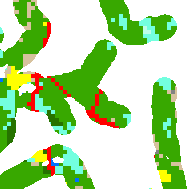 |
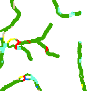
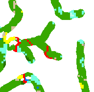
| 100 foot buffer | 200 foot buffer | 300 foot buffer (Figure 1) |
The land cover and land cover change data for the 100 foot and 300 foot buffer zones were summarized by basin to characterize the status of coastal riparian areas. Complete data tables were done for both the 100 and 300 foot buffer zones. The results, in very large spreadsheets, are in the Land Cover in Riparian Zones by Sub-regional Basin section of the Detailed Results page.
In order to somewhat simplify the results for the purposes of characterizing the riparian areas, the CLEAR land cover data was condensed into three categories (other than water). This “simplified land cover” was as follows:
The information surrounding natural vegetation is available in the Focus on Natural Vegetation section of Detailed Results page.
The Niantic Bay watershed was selected for the high resolution classification. Coastal, high resolution ADS40 aerial imagery was used for the detailed analysis. This pilot represents the first time that CLEAR researchers have used this quality of imagery and in this manner.
A software called eCognition was used. eCognition groups like pixels together as objects and the objects are used in further analysis. A number of iterations were required to find a way to use the software with the new dataset. The high resolution data is very complex and had very large file sizes. See Appendix J for complete methods.
We were interested in analyzing the buffer zone within the Niantic. When the “to be buffered” file was viewed with the high-resolution, aerial imagery, there were many inconsistencies. This is because the DEP water data was created from the USGS topographic maps. Because of the discrepancy, the “to be buffered” polyline was modified for the Niantic Bay watershed. The 300 foot buffer was then created and used to isolate only land cover within the buffer. Extensive hand editing cleaned up the data.
A classification of the 300ft buffer zone contained six land cover categories: developed, water, sand, forest, field and other vegetation (Figure 1, above).
Read the Project Completion Report for more detailed explanations of the data and techniques. For detailed description of the GIS methods, see Appendix J. The Appendices are not attached to the report. To see the data tables, visit the Detailed Results page. Click here see Appendix A, the two-page public summary.
The Summary document provides a good overview of the project and interesting findings.
Funded by the EPA Long Island Sound Office
Special thanks to the Nonpoint Source Work Group and EPA for recognizing this as important work and funding it.
Contact
CLEAR
clear@uconn.edu
(860) 345-4511