
College of Agriculture and Natural Resources
Center for Land Use Education and Research

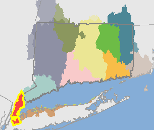 Bronx Basin (02030102)
The Bronx Basin is approximately 172 square miles (110,026 acres). It drains to western Long Island Sound and includes some of the most densely populated and highly developed areas in the watershed.
It includes the following HUC12 basins: East Creek-Mamaroneck Harbor, Flushing Creek-Flushing Bay, Hutchinson River-Eastchester Bay, Kensico Reservoir, Lower Bronx River, Sheldrake River-Mamaroneck River, Upper Bronx River and Westchester Creek-East River.
Visit the Interactive Map to see and compare the maps. Visit the Statistics or Maps page to see the breakdown for the HUC12 basins.
| 1985 | 2010 | Change | ||||
| acres | % | acres | % |
acres | % | |
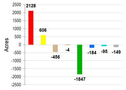
| Developed | 66832 | 60.7% | 68960 | 62.7% | 2128 | 1.9% |
| Turf & Grass | 16022 | 14.6% | 16629 | 15.1% | 606 | 0.6% |
| Other Grass | 1357 | 1.2% | 901 | 0.8% | -456 | -0.4% |
| Ag. Field | 101 | 0.1% | 97 | 0.1% | -4 | 0.0% |
| Deciduous Forest | 19396 | 17.6% | 17651 | 16.0% | -1745 | -1.6% |
| Coniferous Forest | 354 | 0.3% | 333 | 0.3% | -21 | 0.0% |
| Water | 4174 | 3.8% | 3991 | 3.6% | -184 | -0.2% |
| Non-forested Wetlands | 106 | 0.1% | 37 | 0.0% | -68 | -0.1% |
| Forested Wetlands | 634 | 0.6% | 554 | 0.5% | -81 | -0.1% |
| Tidal Wetlands | 349 | 0.3% | 322 | 0.3% | -27 | 0.0% |
| Barren | 576 | 0.5% | 428 | 0.4% | -149 | -0.1% |
| Utility ROW (Forest) | 126 | 0.1% | 125 | 0.1% | 0 | 0.0% |
Change in Zone Land Cover, 1985-2010 |
||
 |
|
|
| Developed | ||
| Turf & Grass | ||
| Other Grass | ||
| Agricultural Field | ||
| Forest | ||
| Water | ||
| Wetland | ||
| Barren | ||
| 1985 | 2010 | Change | ||||
| acres | % | acres | % | acres | % | |
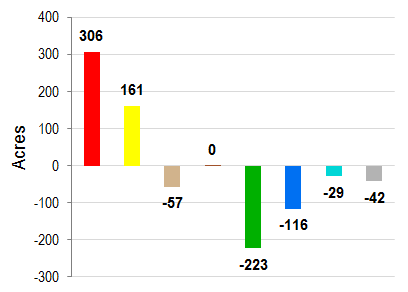
| Developed | 4969 | 41.5% | 5275 | 44.0% | 306 | 2.6% |
| Turf & Grass | 1566 | 13.1% | 1727 | 14.4% | 161 | 1.3% |
| Other Grass | 208 | 1.7% | 151 | 1.3% | -57 | -0.5% |
| Ag. Field | 1 | 0.0% | 1 | 0.0% | 0 | 0.0% |
| Deciduous Forest | 4000 | 33.4% | 3819 | 31.9% | -181 | -1.5% |
| Coniferous Forest | 73 | 0.6% | 68 | 0.6% | -5 | 0.0% |
| Water | 590 | 4.9% | 474 | 4.0% | -116 | -1.0% |
| Non-forested Wetlands | 37 | 0.3% | 15 | 0.1% | -22 | -0.2% |
| Forested Wetlands | 303 | 2.5% | 265 | 2.2% | -38 | -0.3% |
| Tidal Wetlands | 108 | 0.9% | 100 | 0.8% | -7 | -0.1% |
| Barren | 95 | 0.8% | 53 | 0.4% | -42 | -0.3% |
| Utility ROW (Forest) | 26 | 0.2% | 27 | 0.2% | 0 | 0.0% |
Change in Riparian Zone Land Cover, 1985-2010 |
||
 |
|
|
| Developed | ||
| Turf & Grass | ||
| Other Grass | ||
| Agricultural Field | ||
| Forest | ||
| Water | ||
| Wetland | ||
| Barren | ||
| 1985 | 1990 | 1995 | 2002 | 2006 | 2010 | Change | |||||||
| acres | % | acres | % |
acres | % | acres | % | acres | % | acres | % | acres | % |
| 24286 | 3.6% | 24466 | 3.6% | 24558 | 3.7% | 24675 | 3.7% | 24702 | 3.7% | 24882 | 3.7% | 596 | 0.1% |
