Trail Census Home | Help Page | Understanding and Using the Data | Trail Use and Weather
 Visualization Help
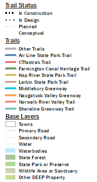
Moving Around the Map | Selecting Trail Counters | Basemap Legend |
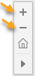 Toolbar. Use the + and - button the toolbar that appears when you mouse over the map. OR
Mouse. Use the wheel on your mouse to zoom in and out.
- The pan tool is selected by default, so if you haven't changed anything, just left-click, hold and drag. You know the pan is active when the mouse changes to ![]() .
.
- If necessary, select the pan button on the toolbar then left-click, hold and drag to move around the map. ![]()
![]() If you get lost, use the home button to go back to the extent of the state.
If you get lost, use the home button to go back to the extent of the state.
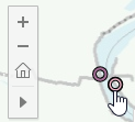 - Click on any donut on the map to select that trail counter site. The name of each counter appears when you mouse over. Notice that in some cases, like the Riverfront Recapture counters in Hartford, there are two counters close enough together that they are difficult to distinguish when looking at the whole state. Zoom in to see both.
More than one counter can be selected at once. The numbers and charts will show combined results of all selected counters.
Select buttons on the toolbar. First, choose one of the three select tools (rectangle, radial, or lasso)![]() and then draw the shape on the map. Any counters falling inside that shape will be selected. Verify your selection by viewing the legend. All selected sites show in the legend.
and then draw the shape on the map. Any counters falling inside that shape will be selected. Verify your selection by viewing the legend. All selected sites show in the legend.
Keyboard keys. Click on a site, hold down the CTRL key and continue clicking on and selecting sites. If a site is already selected, the CTRL-click will unselect it.